| Home | > | List of locations | > | Inhamitanga Forest, Sofala |
Location: Inhamitanga Forest, Sofala
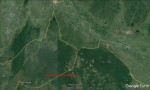
Photo: Google Earth
Map of Inhamitanga - Caia region.
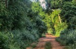
Photo: Bart Wursten
Road 213 through Inhamitanga Forest
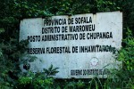
Photo: Bart Wursten
Reserve sign on the northeastern Marrumeo boundary
General Information
Quarter degree square: 1835A2 Country: Mozambique Habitat: Forest and forest edge Altitude range: c. 200m Annual rainfall: Location (short): Location (detailed): |
Description
Useful links
View a list of records for Inhamitanga Forest, Sofala
View a list of unique taxa (excluding cultivated plants) for Inhamitanga Forest, Sofala
View a list of unique taxa (all taxa whether cultivated or not) for Inhamitanga Forest, Sofala
View a list of recorders who have visited this location
| Home | > | List of locations | > | Inhamitanga Forest, Sofala |